Habitat Assessments
We are conducting habitat assessments to better inform protection, restoration, and recovery projects and planning in the upper Cowlitz basin. 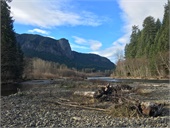
Tacoma Power has been developing a suite of habitat tools (e.g., Geomorphic Assessment, Hydraulic Model) that inform the habitat conditions and trajectories within the upper Cowlitz and Cispus basins. Earlier work included identifying reaches with high-quality habitat potentially suitable for protection.
-
Tacoma Power contracted a hydrodynamic model (2D HEC-RAS) in for the Cowlitz River mainstem in the Packwood-Randle area. The model was used to simulate depth and velocity a five different flows (see map outputs below). The final report (2020) describes model technical details, results, and additional habitat suitability and complexity analyses.
Depth map books: summer average low flow, winter average high flow, 1-year flood, 2-year flood, and 10-year flood.
Velocity map books: summer average low flow, winter average high flow, 1-year flood, 2-year flood, and 10-year flood.
Contact us for associated spatial data and enquiries about using the hydrodynamic model.
-
Tacoma Power contracted a geomorphic assessment in 2019 to evaluate trends over time and future trajectories of the Cowlitz and Cispus River mainstems upstream of Cowlitz Falls. Appendices include maps of Relative Elevation Models and active channel areas over time.
Contact us for associated spatial data.
-
Tacoma Power contracted a topo-bathymetric (blue-green) LiDAR survey of the upper Cowlitz River from roughly Packwood downstream to Lake Scanewa in support of habitat assessment efforts.
Contact us for associated spatial data.
-
Tacoma Power contracted an assessment to identify river reaches suitable for protection through acquisition in 2014. The assessment focused on non-federal lands upstream of Mayfield Dam in the Tilton, upper Cowlitz, and Cispus rivers.
Contact us for associated spatial data.
The Lower Columbia Fish Recovery Board, with support from Tacoma Power, has developed an Upper Cowlitz and Cispus Habitat Strategy. The outcome of this effort, focused upstream of Cowlitz Falls, is a habitat strategy comprised of over 100 potential actions (restoration and protection measures) to support listed salmonid recovery.